What is a Local Cycling & Walking Infrastructure Plan?
The Local Cycling & Walking Infrastructure plan's purpose is to enable a long-term approach to identifying cycling and walking improvements required at the local level.
By taking a strategic approach to improving conditions for cycling and walking, the Local Cycling and Walking Infrastructure Plan will assist the Council to:
- Identify cycling and walking infrastructure improvements for future investment in the short, medium and long term
- Ensure that consideration is given to cycling and walking within both local planning and transport policies and strategies
- Make the case for future funding for walking and cycling infrastructure
Consultation on the Isles of Scilly Local Cycling and Walking Infrastructure Plan
In 2022, following funding received from the Department of Transport (DfT), the Council appointed a consultant to support development of the first Local Cycling and Walking Infrastructure Plan (LCWIP). Public and stakeholder consultations began in June 2022 with a consultation draft developed in accordance with Government guidance, with some adaptions reflecting the Isles of Scilly's rural geography and particular characteristics. The Local Walking and Cycling Infrastructure Plan 2023 was adopted by members at the full Council meeting on 14th December 2023.
You can view the LCWIP document to the right of this page.
The Local Cycling and Walking Infrastructure Plan contains the following information:
- details the governance and the geographical context of the plan
- details of stakeholder and public engagement
- Data used in support of the proposals, largely to enable prioritisation of schemes based on where most demand for walking and cycling was found
- Appraisals of the quality and suitability of existing networks for cycling and walking, covering issues such as the width and quality of pavements, safety at junctions, traffic speeds, and 'missing links' for walking and cycling
- Design principles, and from this, a prioritised list of schemes with most schemes given a high priority due to the cost of importing materials and machinery to the islands. Flagship schemes include widening and improving the island's pavements and providing better cycling and walking along the route known as the 'Dump path'.
The Local Cycling and Walking Infrastructure Plan details a range of potential priority schemes including:
- a segregated or shared use path for walking and cycling on the route known as the 'Dump path'
- resurfacing the highways, which weren't resurfaced in 2014
- wider pavements, with an aspiration to achieve 1.5m as the minimum, where available space permits it
- reducing conflict on Hugh Street by the Co-Op and at other locations where parking causes safety concerns
- improvements at key junctions to reduce the speed on interaction, giving people more time to avoid potential collisions and pedestrians more confidence to cross at junctions
- School streets or other measures to reduce vehicle speeds in the vicinity of the main routes to school
- Localised measures on the island's road network to reduce the higher speeds, especially where people are sharing the carriageway on foot of cycle
- A new weatherproof cycle storage unit on St Mary's Quay, which will be used by off-islanders continuing their journey on St Mary's.
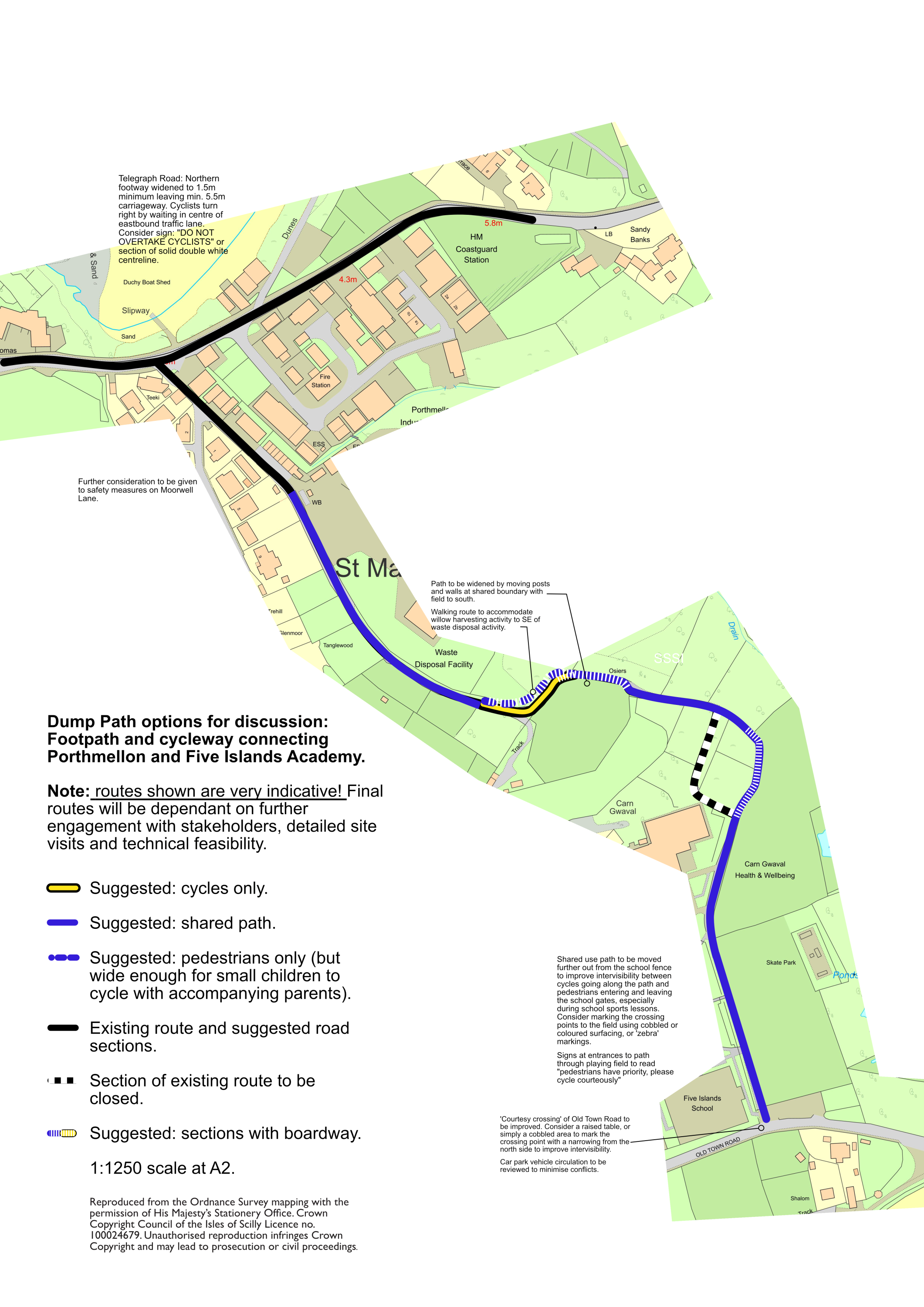
Scheme Designs for the 'Dump Path'
The Local Cycling and Walking Infrastructure Plan highlights the Dump path route has a high priority because it's on a school route and the existing path is in poor condition and also very busy, with conflicts between pedestrians and cyclists particularly on the tight and narrow corners. Feedback from the public during the consultations confirmed that this route is deemed a high priority by residents.
The Council consulted residents and stakeholders on sketch design plans for the 'Dump Path' flagship project in October 2023. We are now working with Sustrans to develop the scheme designs further.
The draft sketch drawings for the Dump path scheme are presented below.